Difference between revisions of "File:NauticalAlmanac18thC.jpeg"
From Bidston Observatory
Jump to navigationJump to search (Government approved nautical almanac with tables of computed lunar distances. Early use of computational static tables for assigning a latitude and longitude to a world in process.) |
|||
| Line 1: | Line 1: | ||
== Summary == | == Summary == | ||
| − | Government approved nautical almanac with tables of computed lunar distances. Early use of computational static tables for assigning a latitude and longitude to a world in process. | + | Government approved nautical almanac with tables of computed lunar distances. Early use of computational static tables for assigning a latitude and longitude to a world in process. Used with a sextant (from 19thC rated at Bidston), quadrant and navigational tables. Often used together with Chronometer and Dead Reckoning. |
| + | |||
| + | [[Category:Instruments]] | ||
| + | [[Category:Grey Literature]] | ||
Latest revision as of 08:17, 17 April 2022
Summary
Government approved nautical almanac with tables of computed lunar distances. Early use of computational static tables for assigning a latitude and longitude to a world in process. Used with a sextant (from 19thC rated at Bidston), quadrant and navigational tables. Often used together with Chronometer and Dead Reckoning.
File history
Click on a date/time to view the file as it appeared at that time.
| Date/Time | Thumbnail | Dimensions | User | Comment | |
|---|---|---|---|---|---|
| current | 08:15, 17 April 2022 | 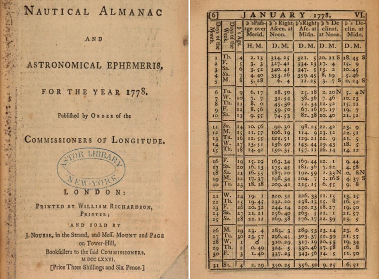 | 760 × 559 (105 KB) | CritterCompiler (talk | contribs) | Government approved nautical almanac with tables of computed lunar distances. Early use of computational static tables for assigning a latitude and longitude to a world in process. |
You cannot overwrite this file.
File usage
There are no pages that use this file.