Difference between revisions of "Performative interface for spectroscosmic meteo matter"
From Bidston Observatory
Jump to navigationJump to search| (26 intermediate revisions by 3 users not shown) | |||
| Line 1: | Line 1: | ||
| − | A realtime activation of the [[ | + | <div class="box">A realtime activation of the [[Weather_Station|weather station]] in which the room/space and its technocosmic atmospheric surroundings become a collective embodied visual and sonic apparatus for speculative neurological processing.</div> |
| + | |||
| + | [[File:meteocosmic-interface.png|thumbs|500px]] | ||
== Meteocosmic == | == Meteocosmic == | ||
| Line 8: | Line 10: | ||
* geophone - Sensor for measuring the 'trembling' of the earth. A microcontroller Axoloti, sonifies the variation in amplitude into a modulated oscillation | * geophone - Sensor for measuring the 'trembling' of the earth. A microcontroller Axoloti, sonifies the variation in amplitude into a modulated oscillation | ||
* contact mic | * contact mic | ||
| + | |||
| + | <gallery caption="" widths=125px perrow=4> | ||
| + | File:1-Bidston-downdwarsdela-ext5.jpg|thumb|120px| 1 | ||
| + | File:2-Bidston-downdwarsdela-ext26.jpg|thumb|120px| 2 | ||
| + | File:2-Bidston-downdwarsdela-ext37.jpg|thumb|120px| 2 | ||
| + | </gallery> | ||
== Emf frequencies == | == Emf frequencies == | ||
| Line 14: | Line 22: | ||
* metal detector | * metal detector | ||
* rtl-sdr > Software defined radio receives AIS frequency -162.025 MHz | * rtl-sdr > Software defined radio receives AIS frequency -162.025 MHz | ||
| − | * [Electromagic_SSTV_transmitter] | + | * [[Electromagic_SSTV_transmitter]] |
* gps usb device which run on gps-d logs the following data: | * gps usb device which run on gps-d logs the following data: | ||
**- position - latitude - longitude - time utc - altitude (m) - speed (m/s) - climb - track - mode | **- position - latitude - longitude - time utc - altitude (m) - speed (m/s) - climb - track - mode | ||
| + | |||
| + | |||
| + | <gallery caption="" widths=125px perrow=4> | ||
| + | File:5-Bidston-downdwarsdela-ext17.jpg|thumb|120px| 5 | ||
| + | File:5-Bidston-downdwarsdela-ext18.jpg|thumb|120px| 5 | ||
| + | File:5-Bidston-downdwarsdela-ext20.jpg|thumb|120px| 5 | ||
| + | File:9-Bidston-downdwarsdela-ext23.jpg|thumb|120px| 9 | ||
| + | File:9-Bidston-downdwarsdela-ext25.jpg|thumb|120px| 9 | ||
| + | File:9-Bidston-downdwarsdela-ext29.jpg|thumb|120px| 9 | ||
| + | File:9-Bidston-downdwarsdela-ext41.jpg|thumb|120px| 9 | ||
| + | </gallery> | ||
| + | |||
| + | == Data Sonification == | ||
| + | |||
| + | <code> | ||
| + | |||
| + | Liverpool | ||
| + | |||
| + | 1 0.0410700 7.2000 220.190 | ||
| + | 2 0.0821400 2.0000 108.490 | ||
| + | 3 0.5443700 3.1000 242.280 | ||
| + | 4 1.0159000 1.2000 221.750 | ||
| + | 5 1.0980300 2.3000 198.880 | ||
| + | 6 12.8542900 0.8000 293.910 | ||
| + | 7 12.9271402 0.2000 125.060 | ||
| + | 8 13.3986597 3.6000 350.480 | ||
| + | 9 13.4715099 0.9000 347.140 | ||
| + | 10 13.9430399 11.3000 41.900 | ||
| + | 11 14.0251703 1.5000 287.110 | ||
| + | 12 14.5695496 0.2000 107.740 | ||
| + | 13 14.9178600 0.1000 117.280 | ||
| + | </code> | ||
| + | |||
| + | Ceda Archive : MIDAS: UK Mean Wind Data - 1969-1971 | ||
| + | [[https://data.ceda.ac.uk/badc/ukmo-midas/data/WM/yearly_files]] | ||
| + | |||
| + | Data is downloaded in comma separated fields. | ||
| + | Raw data import in Audacity modulated. | ||
| + | |||
| + | * midas-open_uk-mean-wind-obs_dv-201901_merseyside_01128_bidston_qcv-1_1969.csv | ||
| + | * midas-open_uk-mean-wind-obs_dv-201901_merseyside_01128_bidston_qcv-1_1970.csv | ||
| + | * midas-open_uk-mean-wind-obs_dv-201901_merseyside_01128_bidston_qcv-1_1971.csv | ||
| + | |||
| + | |||
| + | [[File:20210806_234758.jpg|500px]] | ||
| + | |||
| + | [[Category:Contributions]] [[Category:Instruments]] | ||
Latest revision as of 04:42, 17 April 2022
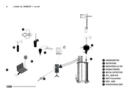
A realtime activation of the weather station in which the room/space and its technocosmic atmospheric surroundings become a collective embodied visual and sonic apparatus for speculative neurological processing.
Meteocosmic
- anemometer
- paper dimension ? 25,4cm x 41cm -15 3⁄4 inch x 10inch on a vertical cylindric plate
- an audiovisualizer pointing on the paper producing a lissajou pattern depending on the resonance of the vibrating membrane (circular 8cm)
- wind recording or live capturing with ZOOM H4 recorder
- geophone - Sensor for measuring the 'trembling' of the earth. A microcontroller Axoloti, sonifies the variation in amplitude into a modulated oscillation
- contact mic
Emf frequencies
- vhf - BAOUFENG UV-5R- automatic scan
- signal finder
- metal detector
- rtl-sdr > Software defined radio receives AIS frequency -162.025 MHz
- Electromagic_SSTV_transmitter
- gps usb device which run on gps-d logs the following data:
- - position - latitude - longitude - time utc - altitude (m) - speed (m/s) - climb - track - mode
Data Sonification
Liverpool
  1               0.0410700      7.2000    220.190
  2               0.0821400      2.0000    108.490
  3               0.5443700      3.1000    242.280
  4               1.0159000      1.2000    221.750
  5               1.0980300      2.3000    198.880
  6              12.8542900      0.8000    293.910
  7              12.9271402      0.2000    125.060
  8              13.3986597      3.6000    350.480
  9              13.4715099      0.9000    347.140
 10               13.9430399     11.3000     41.900
 11               14.0251703      1.5000    287.110
 12               14.5695496      0.2000    107.740
 13               14.9178600      0.1000    117.280
Ceda Archive : MIDAS: UK Mean Wind Data - 1969-1971 [[1]]
Data is downloaded in comma separated fields. Raw data import in Audacity modulated.
- midas-open_uk-mean-wind-obs_dv-201901_merseyside_01128_bidston_qcv-1_1969.csv
- midas-open_uk-mean-wind-obs_dv-201901_merseyside_01128_bidston_qcv-1_1970.csv
- midas-open_uk-mean-wind-obs_dv-201901_merseyside_01128_bidston_qcv-1_1971.csv


