File:Computed Table of moon position.png
Computed_Table_of_moon_position.png (383 × 496 pixels, file size: 236 KB, MIME type: image/png)
Summary
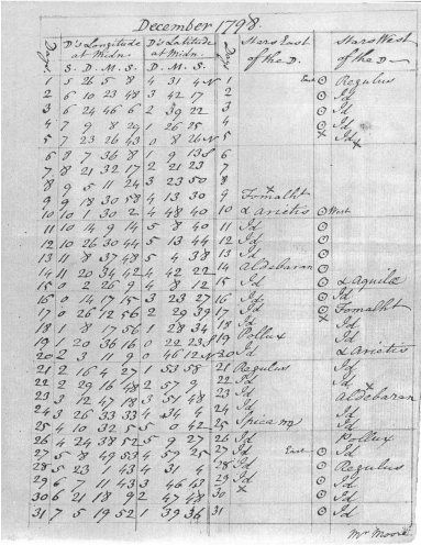
Table of moon’s position at midnight showing which stars to use for lunar distance predictions. Sent by Malachy Hitchins to Joshua Moore for midnight December 1798. (Courtesy of Library of Congress.)
Government approved nautical almanac with tables of computed lunar distances. Early use of computational static tables for assigning a latitude and longitude to a world in process. Used with a sextant (from 19thC rated at Bidston), quadrant and navigational tables. Often used together with Chronometer and Dead Reckoning.
File history
Click on a date/time to view the file as it appeared at that time.
| Date/Time | Thumbnail | Dimensions | User | Comment | |
|---|---|---|---|---|---|
| current | 08:36, 17 April 2022 | | 383 × 496 (236 KB) | CritterCompiler (talk | contribs) | Table of moon’s position at midnight showing which stars to use for lunar distance predictions. Sent by Malachy Hitchins to Joshua Moore for midnight December 1798. (Courtesy of Library of Congress.) Government approved nautical almanac with tables of computed lunar distances. Early use of computational static tables for assigning a latitude and longitude to a world in process. Used with a sextant (from 19thC rated at Bidston), quadrant and navigational tables. Often used together with Chron... |
You cannot overwrite this file.
File usage
There are no pages that use this file.